Weather
Weather news from McAllen and the Rio Grande Valley.

 Weather
Record heat continues as the Valley stays clear of Tropical Storm Bertha
HARLINGEN, Texas (ValleyCentral) — We have two big weather stories: the heat and hot temperatures with the possibility of breaking, if not tying, records, but also Tropical Storm Bertha in the northern Gulf. Tropical Storm Bertha Tropical Storm Bertha is the second tropical storm of the Atlantic Season and the second storm to form along
WeatherRecord heat continues as the Valley stays clear of Tropical Storm Bertha
HARLINGEN, Texas (ValleyCentral) — We have two big weather stories: the heat and hot temperatures with the possibility of breaking, if not tying, records, but also Tropical Storm Bertha in the northern Gulf. Tropical Storm Bertha Tropical Storm Bertha is the second tropical storm of the Atlantic Season and the second storm to form along
 Weather
Tropical Storm Bertha brings very hot conditions to the Rio Grande Valley
HARLINGEN, Texas (ValleyCentral) -- Tropical Storm Bertha is the second tropical storm of the Atlantic Season and the second storm to form along the U.S. Gulf Coast. Bertha is not expected to develop into a hurricane but to remain a tropical storm. On Thursday, Bertha will encounter land on the Louisiana coast as it tracks
 Weather
Governor Surveys Flood-Damaged Areas, Provides Update On Texas’ Severe Weather Response
Governor Greg Abbott conducted an aerial survey of flood-affected areas in Texas, providing updates on the state's response to last week's severe flooding. He expressed gratitude to first responders and volunteers for their efforts. The state has identified approximately 490 homes with damage and is collaborating with local officials to expedite debris removal and rebuilding efforts. Abbott emphasized the importance of monitoring local forecasts and avoiding flooded roads. Resources for recovery and assistance can be found at disaster.texas.gov and TexasReady.gov, as Texas maintains a heightened response posture to support affected communities.
 Weather
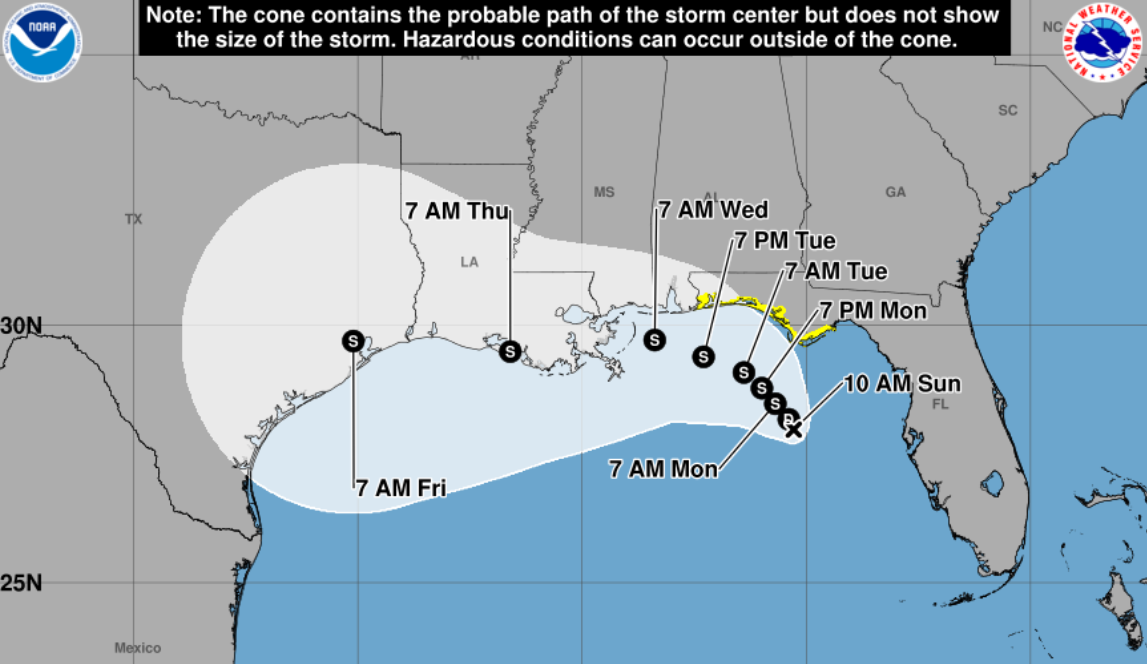
Tropical Storm Bertha Forms in the Gulf; Areas That May Be Affected
MIAMI – Tropical Storm Bertha formed on Monday after Tropical Depression Two intensified, according to the National Hurricane Center (NHC). As of the latest bulletin at 8 PM, the system was located 110 miles south of Panama City, with maximum sustained winds of 40 mph and a minimum pressure of 1004 mb, moving northwest at about 3 mph. According to the forecast track, Bertha is expected to move near or along the northern Gulf coast over the next few days, with the possibility of further strengthening. The latest forecast indicates that the NHC is closely monitoring the system as it approaches the Florida Panhandle, an area for which a tropical storm watch has already been issued. Tropical storm conditions could be experienced in this area from late tonight through Tuesday, potentially extending into Wednesday. The combination of storm surge and tide will likely cause flooding in normally dry areas near the immediate coast due to rising water levels moving inland from the shoreline. Watches and Warnings: A tropical storm watch is in effect from the Ochlockonee River to the Florida-Alabama border. A storm surge watch is in effect from the Alabama-Florida border to the mouth of the Mississippi River.
 Weather
Starr County Judge Signs Disaster Declaration Due to Armyworm Threat
Starr County Judge Eloy Vera announced on his social media that he has signed a local disaster declaration due to the threat of the New World armyworm in the region. This is a developing story. We will provide more details as they become available.
 Weather
Tropical storm could form later today in the Gulf
Tropical Depression Two is expected to become Tropical Storm Bertha on Monday as the depression moves northwestward, the National Hurricane Center announced.
 Weather
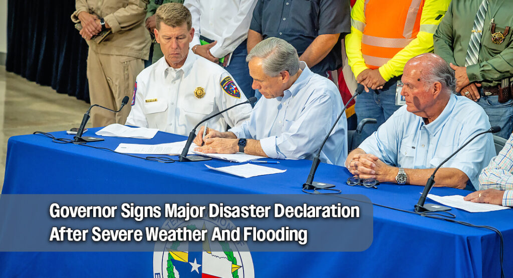
Governor Signs Major Disaster Declaration After Severe Weather And Flooding
Governor Greg Abbott has requested a Presidential Disaster Declaration to assist Texas communities affected by severe weather and flooding. During a visit to Uvalde County, he assessed damage and met with local officials and first responders. Abbott announced that he is seeking federal aid for 28 counties, with the possibility of adding more as needed. Over 2,700 personnel and 1,500 resources have been deployed statewide, resulting in more than 270 rescues. The Governor urged residents in Uvalde and surrounding counties to stay vigilant as additional severe weather may occur. State agencies are providing ongoing support to affected areas.
 Weather
The Valley will simmer in summer-time heat
HARLINGEN, Texas (ValleyCentral) — Caution is being advised for afternoon outdoor activities as the combination of heat and humidity will be raising the heat index to 108-112 in many areas. This is what it will feel like to us during the hottest part of the day today. Remember these tips to help keep yourself and
 Weather
Tropical depression forms in gulf, may threaten Texas coast
A tropical depression formed in the eastern Gulf of Mexico on Sunday, prompting the National Weather Service to issue a tropical storm watch for parts of the Florida Panhandle while forecasting potential impacts for Alabama, Mississippi, Louisiana, and Texas.
 Weather
Tropical Depression Two Forms in the Gulf; Tropical Storm Watch Issued for Florida Areas
Tropical Depression Two has formed in the Gulf of Mexico and is expected to strengthen over the coming days, according to the National Hurricane Center (NHC). As of the latest update, the system was located 155 miles south of Panama City, with maximum sustained winds of 30 mph and a minimum pressure of 1011 mb, moving north-northwest at approximately 3.5 mph. A tropical storm watch has been issued for areas from the Ochlockonee River to the Florida-Alabama border. The NHC is closely monitoring the system, which has shown persistent convection, although its circulation remains broad and weak.
 Weather
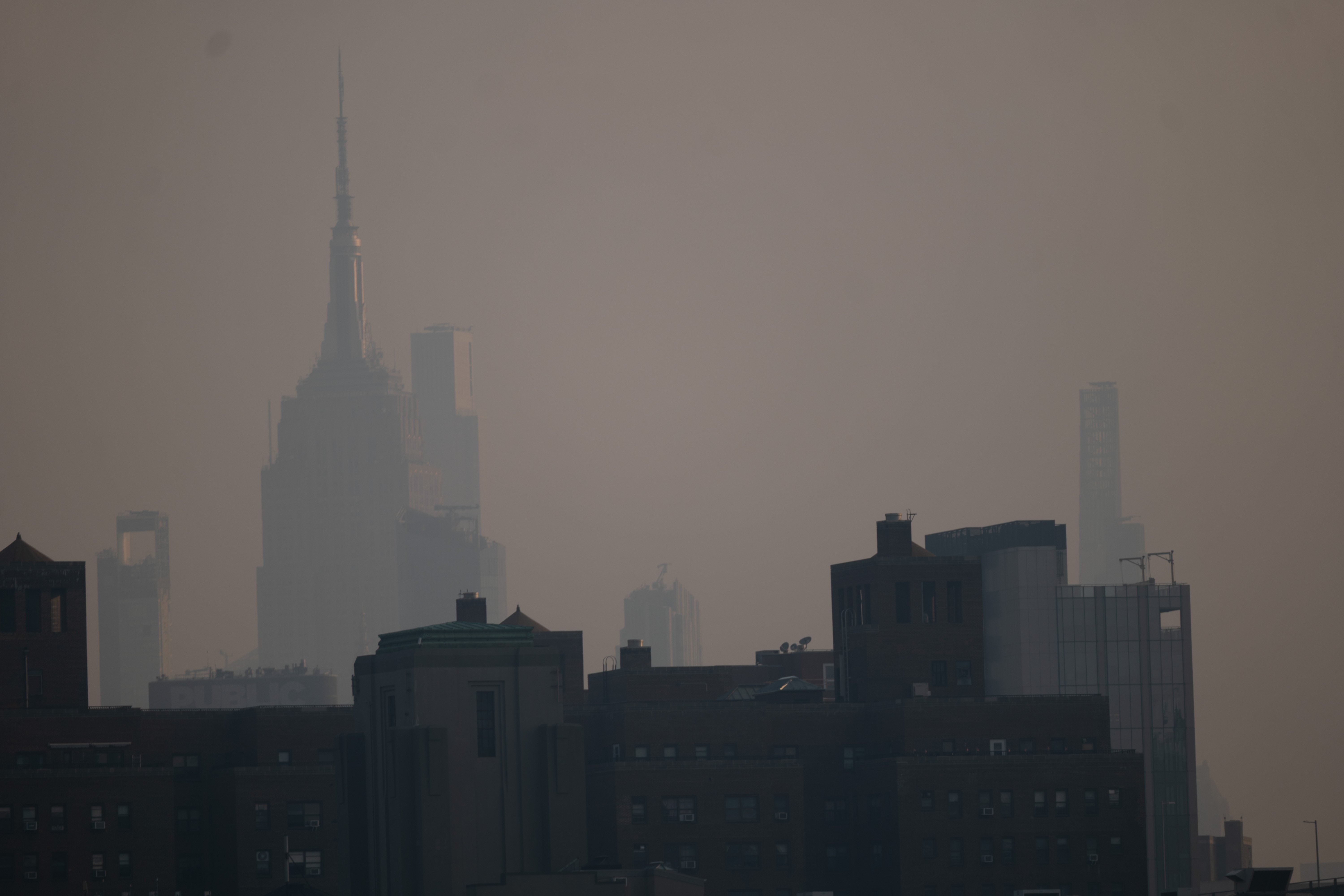
Rain Expected to Clear Smoke from Canadian Wildfires for World Cup Final
Meteorologists predict that smoke from Canadian wildfires, which has blanketed the Northeast, will largely dissipate in New Jersey just in time for the 2026 World Cup final on Sunday, thanks to incoming thunderstorms. On Saturday, air quality alerts remained in effect across much of the U.S. Heavy rain and thunder were reported at MetLife Stadium, where attendees were urged to seek shelter. New Jersey Governor Mikie Sherrill warned of potential damaging winds and flash floods. Spain's training session before the final against Argentina was canceled due to storms. FIFA is closely monitoring the situation with local authorities.
 Weather
Saharan dust and dry conditions continue this weekend
HARLINGEN, Texas (ValleyCentral) — The weekend is finally here, and good news: the forecast shows dry skies with no rain in sight. Also, the weather won’t be getting in the way of any plans. However, if you were hoping the Saharan dust had wrapped up its visit, not quite yet. While a break is on the horizon, we’ll have to wait a bit
 Weather
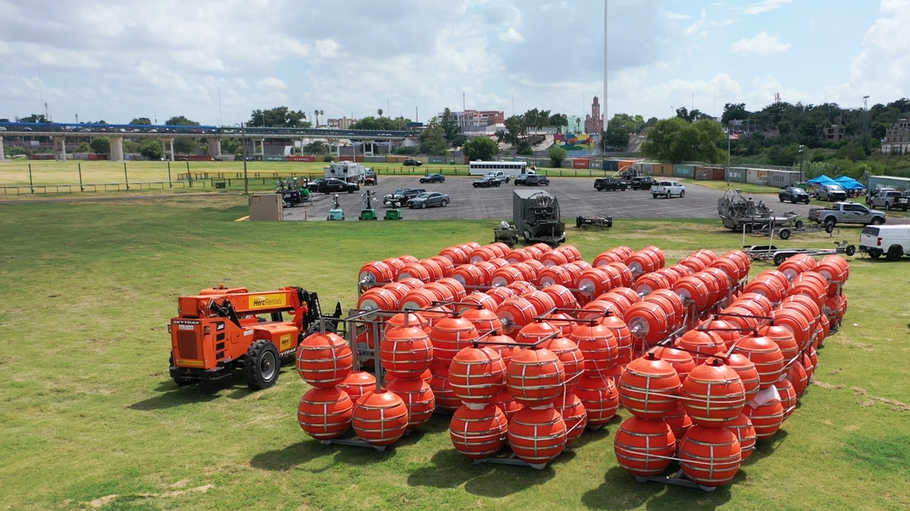
Heavy Rains and Storms Cause Buoys to Dislodge in Eagle Pass
Due to rising levels of the Rio Grande from heavy rains and storms, several border buoys became dislodged in the Eagle Pass area. We reached out to CBP for a statement, and a spokesperson from the agency provided the following information. "As a result of the heavy rains recorded this week in Eagle Pass, Texas, the buoys near Shelby Park, which were under the responsibility and control of the contractor, were swept into the river due to the rapid rise in water levels. These were not buoys that were already installed and anchored in the river. CBP is working with its contractor to recover these buoys." "The water barriers are intended to create a safer border environment for agents conducting patrols, as well as to deter migrants from attempting to cross the border illegally through dangerous waterways. They also provide effective impediment and deterrence capabilities that reinforce natural barriers and complement nearby steel bollard border wall systems," said the CBP spokesperson.
 Weather
Triple-digit heat ahead in the Valley
HARLINGEN, Texas (ValleyCentral) — The general trend heading into the weekend is hot, rain-free and turning hotter through early next week. This Friday will see highs in the upper 90s for the majority of the Valley. A mix of sun and clouds with highs peaking in the upper 90s. Wind gusts from the southeast around
 Weather
Gov. Abbott Warns of ‘Record-Breaking’ Floods, Confirms 2 Fatalities in Texas
Governor Greg Abbott held a press conference in Austin to address the severe flooding affecting Texas, confirming two fatalities. He emphasized that protecting lives is the top priority as record-breaking rainfall continues. Over 2,350 emergency responders and more than 1,400 vehicles have been deployed to assist local communities. Abbott urged Texans to heed safety warnings and avoid driving through flooded areas, reminding them to 'Turn Around, Don’t Drown.' He also directed state agencies to remain active in their support efforts as dangerous flooding persists in various regions, including the Texas Hill Country and South Texas.
 Weather
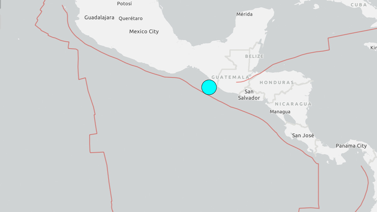
7.4 Magnitude Earthquake Recorded Off the Coast of Guatemala and Mexico
A preliminary earthquake of magnitude 7.4 struck off the coast of Guatemala and Mexico on Friday morning, according to the U.S. Geological Survey (USGS). The epicenter was located 44 miles west-southwest of Puerto Madero, near Chiapas. Following the main quake, there were several aftershocks, with magnitudes of 6.0, 5.3, and 5.1 reported. The Chiapas Meteorological Agency noted a total of seven aftershocks of magnitude 5.0 or greater, with the largest being 6.4. Authorities warned of potential tsunami waves affecting the coasts of Mexico and Guatemala, with sea level variations expected to reach up to 105 centimeters.
 Weather
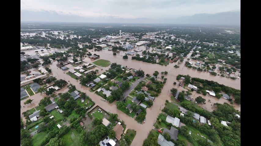
Two deaths reported as flash flooding triggers urgent warnings across southwest Texas, Hill Country
Flash floods in southwest Texas have resulted in two fatalities and over 200 rescues, as reported by Governor Greg Abbott. The hardest-hit areas, including Uvalde and Kerr County, received up to 28 inches of rain in just three days. Rescuers, including over 2,000 first responders, have been deployed to assist those trapped in homes and vehicles. The floods, reminiscent of last year's disaster, prompted urgent warnings for residents to seek higher ground. While some areas experienced significant flooding, levels remained below last year's record highs. Many residents reported better preparedness this time around, with more alerts issued.
 Weather
More heat, more haze and more dry weather on the way
HARLINGEN, Texas (ValleyCentral) — A stubborn high‑pressure ridge stays locked over the Gulf, keeping conditions dry, warm and hazy. With that sinking air overhead, temperatures stay hot and slightly above average, especially for the western regions of the Rio Grande Valley. The setup also encourages southerly winds, so the weekend won’t just be warm, it’ll feel more humid too. Most of the weekend trends partly to