Gulf Alert: Texas Coast Remains Under Tropical Storm Watch
· Telemundo McAllen (KTLM)
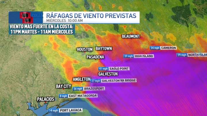
HOUSTON – A tropical storm watch remains in effect for the coastal areas of Brazoria, Galveston, and Chambers counties as a tropical low pressure system moves parallel to the Texas coast and could potentially develop into tropical cyclone Arthur by Wednesday, with minimal impacts expected in this region. The National Hurricane Center (NHC) maintains the projected path of the system near the Texas coast, with expected movement over southeast Texas on Wednesday. 6:30 PM Radar Update: Showers/thunderstorms are tapering off. Expect a lull in precipitation this evening and overnight. Storms are expected to redevelop early tomorrow morning. Remember that flooded areas can stick around even after the rain stops. Turn around don’t drown! pic.twitter.com/JqazoktynE — NWS Houston (@NWSHouston) June 16, 2026 While there is a possibility that it may remain a tropical low pressure or depression in the morning and strengthen later, it is also possible that it may not fully organize. In any scenario, the impacts for our region would be similar. The main effects are expected in coastal areas. Communities under tropical storm watch could experience wind gusts between 30 and 45 mph, while other areas in southeast Texas could see gusts ranging from 25 to 30 mph. Additionally, a storm surge of 1 to 4 feet could lead to coastal flooding. Intense rainfall associated with the system would also increase the risk of urban and flash flooding, especially south of Interstate 10, where locally intense rain bands could develop.
AI summary · Source: Telemundo McAllen (KTLM) →